Other Case Studies
The SMART partnership supports improved law enforcement and biological monitoring in protected areas around the world. They came to Refractions to build a software tool to help meet their needs.
Hectares BC – Biodiversity BC on behalf of a broad partnership
Biodiversity BC and its government and non-government partners were looking for regional-level environmental statistics. Refractions proposed a new approach to generating GIS summaries, using the power of a relational database and web tools to provide GIS analysis to users who previously had no access to it.
Automated Route Planning for Meter Reading – City of Vancouver
The City of Vancouver collects water readings from thousands of residences and businesses, but has never optimized the pedestrian routes the readers take. Refractions developed algorithms to create the most efficient routes of the correct length for readers.
Digital Road Atlas – BC Integrated Land Management Bureau
Refractions provides full-service support for the British Columbia Digital Roads Atlas – systems design, maintenance, data conflation, client service, and rapid response.
Caribou Habitat Assessment and Supply Estimator – Wildlife Infometrics Inc.
Refractions converted a legacy habitat modelling system based on ArcView 3.X to ArcGIS 9.2, and automated the workflow to provide faster turnaround time for model runs.
Line Cleaner – BC Ministry of Forests
The British Columbia Ministry of Forests needed a tool to conflate multiple roads databases into a single working layer. Refractions delivered the algorithms and a user interface based on the uDig platform.
Interest Reports – BC Ministry of Agriculture & Lands
Refractions developed an ArcMap extension to automate the calculation of standard reports joining a massive shape-file archive with a large Oracle database.
Mobile GIS – UN Food & Agriculture Organization
UN FAO needed a data collection tool that could run disconnected and didn't have a per-seat licensing cost. Refractions delivered a simple tool using the uDig desktop platform.
Open Web Services, Phase 3 – Open Geospatial Consortium
The Open Geospatial Consortium runs regular “testbed” projects to field-test new concepts in geospatial interoperability. Refractions was a part of the OWS-3 initiative, and built a uDig-based “GeoDSS” client to provide access to several other OGC standard services, including a prototype GeoVideo service.
Natural Language Spatial Search Engine for Rental Places-Rento
Rento is a free web service that makes it easy to find a place to rent in Greece. Powered by PostgreSQL and PostGIS, it provides ad listings with photographs displayed on a map. Searching is accomplished through map navigation and natural language processing, with the search engine being capable of answering complex (spatial) questions such as "flat near the University of Athens" or "loft up to 800 euros near a metro station" (in greek).
Hectares BC
A Collaborative Environmental Analysis System for British ColumbiaProject Background
Scientists, researchers, environmental groups, government agencies and others carry out planning, assessment, reporting and decision making functions pertaining to BC's environmental and natural resources. In doing so, standard GIS projects are used in which:
- multiple data layers are collected and processed;
- the layers are overlaid;
- a number of variables of interest are summarized for summary areas of interest; and,
- a report is written based on the summary numbers.
However, the first two steps are often highly redundant, with different groups collecting, processing and summarizing the same core data over and over and over. Worse, whenever the summary areas are changed, the whole process is often repeated.
In early 2007 Biodiversity BC, on behalf of a broad partnership of government and non-government partners, submitted a proposal to the federal GeoConnections initiative, to turn this database analysis concept into a user-friendly system accessible to everyone with data available via OGC standard interfaces (WMS and WCS). The proposal was accepted, and the Hectares BC project began in mid-2007.
Refractions' Solution
Refractions first tested all the technology pieces we thought could do the job, including multiple databases, and user interface frameworks, and arrived at a collection of open source tools that could be put together into a system:
- PostgreSQL as the database engine, holding the 100 million records of hectare-by-hectare land information.
- GRASS as the rasterization engine, taking the raw vector data and converting it to hectare-by-hectare measurements.
- Google Web Toolkit (GWT) to create a highly interactive web-based user interface.
Using an agile methodology, the Refractions team tackled each component of the user interface in turn:
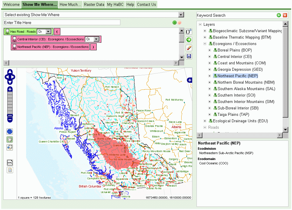
- A “Show me Where” screen, that allows users to create complicated spatial formulas ("where is the slope < 25%, the forest species fir, and the number of frost free days > 200") with a drag'n'drop user interface, then view the results on a map in real time.
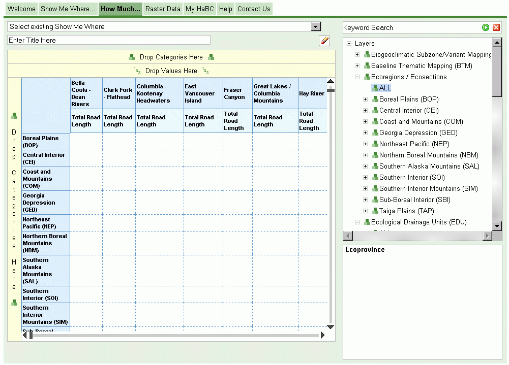
- A “Show my How Much” screen, that allows users to create summaries of the entire land are of the province, in real time, again with a drag'n'drop paradigm.
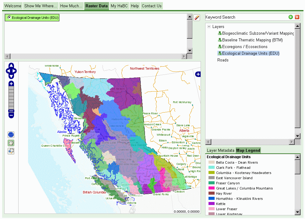
- A “Data Viewer” screen, that allows users to quickly view any of the data layers in the system.
Each screen was built during a three-week development iteration, then brought to the client in a demonstration session, when feedback was used to tune the development priorities for the succeeding iteration. By keeping the steering committee closely involved with development Refractions ensured the development team was always working on features with high priority.